Equatorial Margin of Brazil A Giant Deepwater Hydrocarbon Exploration Frontier in the South Atlantic Realm

December 11, 2022
Get this report
$9,950.00

Report summary

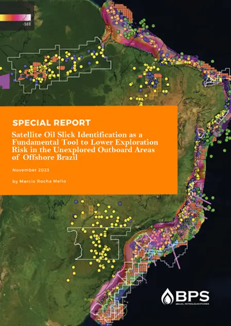
Oil and gas exploration kicked off in the Brazilian Equatorial Margin during the 1970s (e.g., the Foz do Amazonas and Pará-Maranhão basins). However, after almost 40 years of oil exploration, around 121 dry wells were drilled and only 12 sub-commercial wells were discovered. With such results, the campaigns had come to a near halt by the mid-nineties. All wells were drilled in the shallow-water realm during this time. This was followed by the opening of the Brazilian petroleum market with the founding of the National Agency of Petroleum, Natural Gas and Biofuels (ANP) in 1997, which kickstarted new bidding rounds in the Foz do Amazonas, Para-Maranhão and Barreirinhas basins. In recent years, giant oil fields were discovered in the deep waters of the Equatorial Margin of Guyana, Suriname, and French Guyana, which share many similar petroleum system elements and processes as Brazil’s Foz do Amazonas and Pará-Maranhão basins. These discoveries, including the Liza, Payara, Turbot, Ranger Snoek, Pacora, Longtail, Hammerhead, Pluma, Tilapia, Haimara (Guyana), Maka, Sapakara (Suriname) and Zaedyus (French Guyana) fields, have generated massive proven recoverable reserves of light oil, reaching around 8 billion bbl.

Contact us about report

Related reports

July 26, 2023
In order to evaluate the exploratory potential of Barreirinhas Basin, a 2D Petroleum System modeling study was performed aiming to rank the best areas for petroleum exploration in the basin. The study was based on the integration of multidisciplinary approaches and exploration tools including 2D seismic interpretation, high-resolution geochemistry technology, 2D petroleum system modeling and petrophysics.
$38,450.00
July 26, 2023
The application of high resolution geochemistry techniques on oil and rock samples enabled the differentiation and mapping of all oil families and their corresponding source rocks as well as the assessment of the definition of their geographical distribution. 3D petroleum system modelling, calibrated with geological and geochemical data, was performed at a regional scale. BPS built a regional model utilizing the of seismic lines available and it was built with structural maps that encompass the whole sedimentary section.
$49,900.00
July 27, 2023
This 2D petroleum system study comprised the interpretation of more than six thousand kilometers of PSDM seismic lines, providing the basis for subsequent tectonic, structural, and stratigraphic reconstructions, basin modeling, leads definition, petroleum system assessment and risk evaluation.
$29,950.00

Leaving?

Sign up for our newsletter to receive the latest insights and exclusive studies from our experts