Multiclient
3D Petroleum Systems Modeling and Resource Assessment Applied to the Deep and Ultra-Deep Water Realm of the Sergipe-Alagoas Basin, Brazil
Home / Multi-client / 3D Petroleum Systems Modeling and Resource Assessment Applied to the Deep and Ultra-Deep-Water Realm of the Sergipe-Alagoas Basin, Brazil.
Bid Rounds
Multiclient studies available for the upcoming Bidding Rounds
Multi-client
Ongoing Multi-Client Studies
Studies for specific regions
Atlas
BPS, using the largest geochemical, geophysical and geological data set available for the Sergipe-Alagoas Basin, is currently performing an entirely new 3D PSM study of its deep-water area (Figure 1). The study will include all public data from the recently-discovered Upper-Cretaceous light oil and condensate accumulations and will benefit from the expertise of BPS’s exploration team for general G&G, geochemistry and PSM, as well as the latest developments in software (local grid refinement and seismic facies) and computing power. Thus, the study will provide state-of-the-art modeling, incorporating all available geological, geochemical, PVT, petrophysical, biostratigraphy and geophysical data in order to achieve a maximum-resolution and highly accurate 3D compositional model of this deep-water province. The resulting model will serve as a dynamic decision-making tool for potential M&As, exploration programs and well planning.
The petroliferous offshore portion of Sergipe-Alagoas Basin has attracted exploration efforts for oil and gas for a long time. It started with the first offshore discovery ever made in the Brazilian sedimentary basins with the drilling of the 1-SES-1-SES well (Guaricema Field) in the late 1960s. Recently, new giant discoveries have been made in the deep and ultra-deep-waters of the Sergipe Basin and these exploration successes proved the existence of multiple active petroleum systems in the province, naturally raising renewed interest among oil industry players.
These discoveries, which surpass two billion barrels of oil in place, are in close vicinity to several exploration blocks that will be offered or are planned to be offered in the upcoming bidding rounds to be held by the Brazilian National Petroleum Agency (ANP) (Fig. 1). The oils of these Upper Cretaceous turbidity reservoirs were analyzed through our proprietary Advanced Geochemistry Technology (AGT, e.g., QGC-MS-MS, QDA, CSIA-Bh and QEDA) and indicated that they were all sourced from marine-anoxic, organic-rich source rocks of the Albian-Cenomanian/Turonian age and, most importantly, the majority contained highly-mature, lacustrine-brackish light oil and condensates that were sourced by anoxic black shales of the Aptian-Barremian age. In addition, some oils contained abundant concentrations of plant-related biomarkers typical of Maastrichtian and Tertiary oils (Figure 1)
The study specifically addresses such complex oil-mixing questions by utilizing advanced geochemical methods, as well as PVT data. Special focus will be put on facies distribution of source rocks, carrier beds, reservoirs and seals, as partly determined by paleogeography, paleo-topography and locations and directions of sedimentary input, etc.
Spectrum performed a 16,340 linear kms of high-quality 2D PSTM and PSDM seismic data acquisition program in 2014 that covered key wells in the offshore areas of the Sergipe-Alagoas Basin, including all the recent deep-water discoveries such as the Barra, Poça Verde, Cume, Moita Bonita, Muriu and Farfan oil fields. It also reprocessed pre-existing seismic data in the northeastern part of the basin (Alagoas), where channel-fill sediment plays, rifted basin fill and faulted Paleozoic sediments still present good exploration opportunities (Figures 2-3).
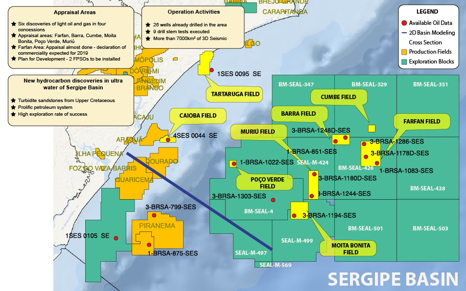
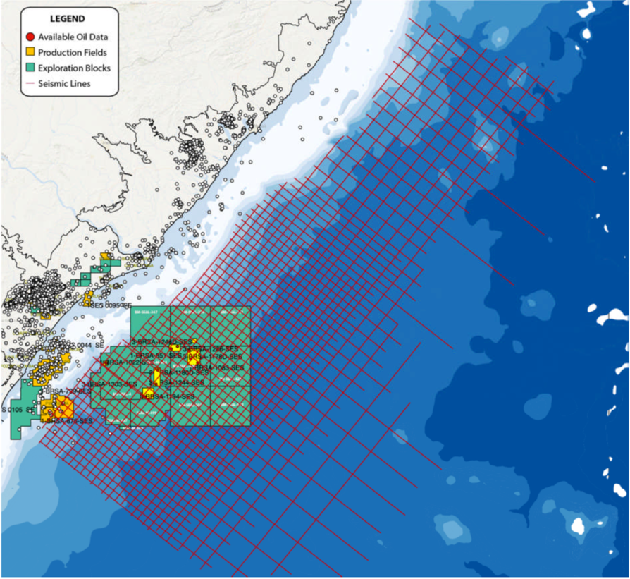
Figure 2. Proposed seismic data to be used in the project, exploration blocks, wells drilled in the basin and deep-water oil fields discovered to date.
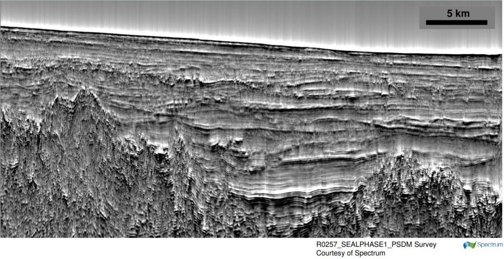
Figure 4. Example of PSDM dip line showing syn- and post-rift targets, as well as possible Moho-equivalent deep reflectors.
PROJECT ROADMAP
This project will comprise, not only PSM itself, but also a variety of parallel/preparatory sub-projects, including:
- The gathering of all publicly available data and BPS proprietary data sets (e.g. oil slicks, oil and source rock data, facies and petrophysical core analyses, PVT data, etc.), review and QC (ongoing).
- Seismic interpretation, using the Spectrum 2D long-offset seismic data, which will provide a set of maps that will allow for the understanding (in regional scale) of the sedimentary fill evolution, the structural and stratigraphic framework of the basin, and the identification (in prospect scale) of the exploration leads in the Upper Cretaceous and Mid and Lower Cretaceous sequences.
- Well analysis, including the revision of the existing concepts, etc., intended to generate a comprehensive map stack covering the model area as an input to the modeling software (Petromod© by SLB, as well as Trinity© by ZetaWare).
- Generate gross-depositional environment (GDP) maps to be used as input facies maps in the model.
- Identification of leads and performance of volume assessment and risk analysis.
- Play type characterization in the area.
- Comprehensive analysis of the petroleum systems in the Sergipe-Alagoas Basin, utilizing geochemistry, play analysis and well data, etc., to obtain an integrated understanding and establish the approach to be used for modeling.
The Petroleum Systems Modelling tasks will follow the best-practices that are well-established in the PSM community worldwide, including:
- Import and QC of all prepared data.
- Map editing and refinement of layering to include dedicated source, seal, and reservoir layers.
- Population of the model with (a. o.) ages, facies maps, paleo-water depth maps, source-rock properties and kinetics, reservoir and seal properties, fault data, a comprehensive heat flow history (separately modeled using specific tools), etc.
- Thorough calibration of the 3D P/T model to maturation proxies (such as vitrinite reflection), BHT, and porosity/pressure data.
- Thorough calibration of the 3D migration model to known accumulations and petroleum properties thereof (GOR, API; PVT, mixing, biodegradation).
- Extensive risking of the obtained Master Model scenario in a multi-scenario approach, intended for sensitivity testing in order to reach conclusions concerning the characteristics of the petroleum systems in the Sergipe-Alagoas Basin.
- Identification of likely areas of occurrence of yet-to-find accumulations, and predictions as to possible volumetric and petroleum properties.